

There are public debates that seem to have run their course because they are constantly repeated, but which are in fact still poorly framed. Rural depopulation is one such debate. For years we have been reading analyses of population loss, an ageing population, the closure of services and regional imbalances. However, a significant part of this debate continues to be framed within an overly narrow, almost exclusively demographic lens, as if everything could be reduced to a declining population curve or a list of municipalities losing residents year after year.
This approach describes part of the problem, but does not explain its underlying dynamics. Because depopulation is not just a question of how many people live in a given area, but of the extent to which that area allows for a viable life to be built. And when analysed from this perspective, a variable immediately emerges that should be at the heart of the conversation: mobility.
Talking about mobility in rural areas does not mean talking solely about roads, buses or journey times. It means talking about real access to employment, healthcare, education, shops, public services and, ultimately, the opportunities that allow a person to decide to stay. For this reason, rather than a secondary consequence of the demographic challenge, mobility is one of its structural factors. Where accessibility weakens, it becomes more difficult for the population to remain. Where the region ceases to connect people with services and opportunities, population loss ceases to be a possibility and begins to become an inertia.
 Patones de Arriba (Madrid) has seen its population grow in recent decades, but it remains similar to that of 1970.
This observation is particularly relevant in regions such as Asturias and, within it, in municipalities such as Aller, where the process of economic and territorial transformation clearly reveals the direct link between connectivity, the functional structure of the territory and demographic trends. The significance of this case lies not only in its figures, but in the way it illustrates a transition recognisable in many other rural areas of Spain: from a productive model that concentrated population and activity to a scenario of dispersion, ageing and territorial fragility.
For much of the 20th century, the development of many rural areas in the north of the peninsula was linked to specific industrial activities, particularly mining. That model not only generated employment but also shaped the territory. The settlements that served as the backbone of productive activity grew, consolidated services and gained relative importance. Mobility, in that context, followed a very specific logic: connecting workers, farms, productive spaces and trading hubs. It was not mobility designed for territorial cohesion in the contemporary sense of the term, but rather to sustain a very specific economic system.
When that system goes into decline, more than just job losses occur. The territorial structure that had sustained the daily lives of thousands of people for decades is completely disrupted. The exodus of young people, the decline in economic activity and the gradual loss of services are not isolated phenomena. They form part of the same sequence. And within that sequence, mobility ceases to be an invisible support and becomes a visible barrier.
This is particularly evident in low-density, vast territories with scattered settlements. In these contexts, the relevant question is not merely how many inhabitants remain, but how they travel, where they go, how long it takes, how much it costs, and what real alternatives they have when private transport is unavailable. That is the question that distinguishes a descriptive analysis from one useful for planning.
Because an area may still have roads, even a public transport line, and yet offer very poor accessibility. There may be a theoretical provision and, at the same time, a practical experience of disconnection. Timetables that clash with working hours or medical appointments, infrequent services, routes ill-suited to actual demand, a lack of integration between transport modes and the absence of flexible solutions are all factors that undermine effective accessibility, even though on paper “the service exists”.
 The Asturian village of Llastres is experiencing a decline in population linked to job losses and poor transport links.
 The Asturian village of Llastres is experiencing a decline in population linked to job losses and poor transport links.
Therein lies one of the cruxes of the problem. Accessibility is not measured solely by the physical presence of infrastructure or the administrative existence of a route. It is measured by the system’s actual capacity to connect people with the destinations they need to reach. And when that capacity diminishes, regional inequality becomes a daily reality. It does not appear solely in statistics, but in concrete decisions: whether or not to accept a job, whether or not to attend a medical appointment, whether or not to continue studying, whether or not to maintain an economic activity, whether or not to stay in the village.
From this perspective, rural depopulation can be understood as a process of progressive loss of territorial functionality. It is not just the villages that are emptying; the network of relationships that allowed those villages to remain habitable is also being depleted. The territory does not cease to be viable overnight. It does so gradually, as its connections diminish, travel becomes more expensive and its margins of opportunity narrow.
In the case of Aller, this interpretation proves particularly revealing. The combination of a large area, relatively low population density and significant internal inequality between settlements and parishes means the territory must be viewed not as a homogeneous unit, but as a system of vastly differing levels of accessibility. There are areas that benefit from their proximity to main transport routes and maintain a certain critical mass. Others, however, find themselves in a peripheral position within the council itself. This spatial difference directly affects the ability to retain population.
When observing the evolution of certain smaller settlements, the link between population loss and the functional weakening of the territory becomes more evident. We are not dealing with a mere statistical decline. We are facing a profound transformation in which some areas no longer meet the minimum conditions required to sustain a competitive daily life compared to other territories. And here the word ‘competitive’ is important: today, territories also compete on the basis of accessibility. They compete for time, for connectivity, for ease of travel, and for functional proximity to essential services.
 Population trends in sparsely populated areas. Source: Spanish Red Cross.
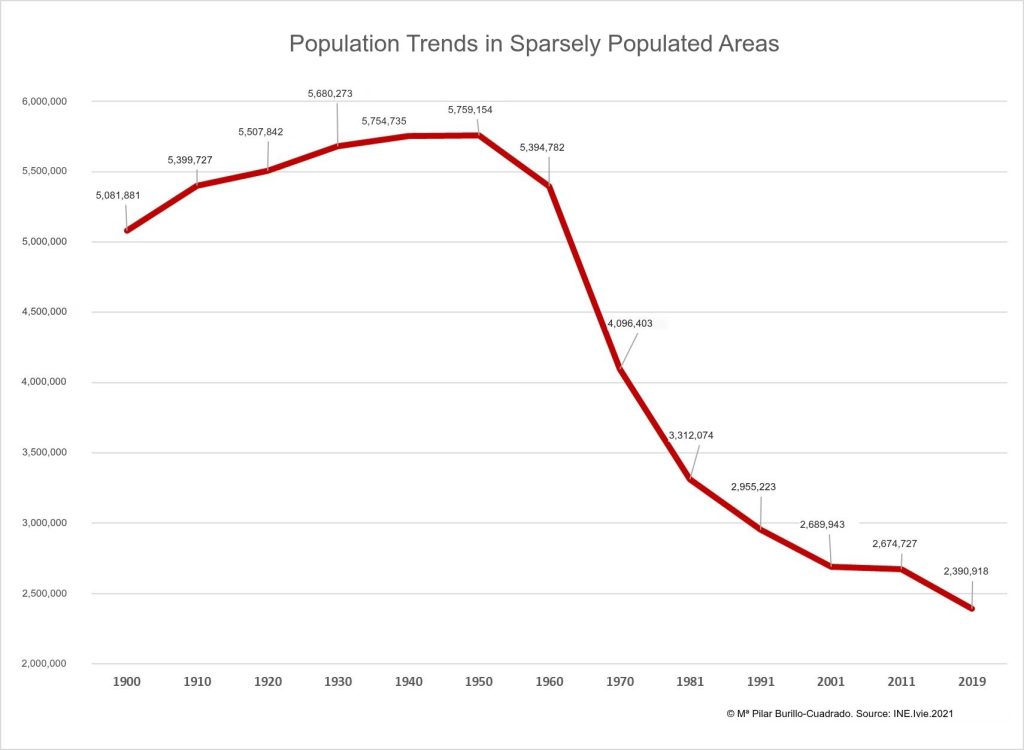 Population trends in sparsely populated areas. Source: Spanish Red Cross.
In this context, continuing to apply transport models designed for urban or densely populated areas to rural areas is a technical and strategic mistake. Conventional public transport, which relies on fixed routes, set timetables and criteria based on sustained demand, has well-known limitations in sparsely populated areas. This is not because public transport is unnecessary, but because the standard model does not fit well with the spatial and temporal realities of these environments.
Rural demand tends to be more fragmented, more variable and less concentrated. The reasons for travel can vary greatly throughout the day and the week. Volumes are lower. Relative distances may be greater. And, above all, the penalty for not having a suitable alternative is much higher than in an urban setting. When an urban service fails, there is usually another option. When it fails in a rural setting, there is often none.
That is why discussing rural mobility today requires moving away from the ‘one-size-fits-all’ approach and towards adaptive solutions. On-demand transport, hybrid models combining fixed networks with flexible services, multimodal integration, the digitalisation of booking and management, and data-driven planning are not technological fads: they are sensible responses to a specific regional problem.
On-demand transport, for example, allows us to rebalance the relationship between supply and actual demand. It is not simply a matter of reducing costs, but of increasing relevance. A service can be more efficient not because it runs less frequently, but because it runs more effectively: when needed, where needed, and with a design better tailored to the population’s mobility patterns. Similarly, integration between different modes and services is key to preventing the last leg of the journey from becoming an insurmountable barrier.
Covarrubias (Burgos) now has a population that is a third of what it was 170 years ago.
 Covarrubias (Burgos) now has a population that is a third of what it was 170 years ago.
Innovation, however, should not be understood merely as the incorporation of technological tools. The key lies in how information is used to interpret the local area. Mobility data, travel times, the location of essential services, ageing patterns, the distribution of employment and the concentration of facilities all enable much more detailed analyses to be carried out. And these analyses are essential for designing effective policies.
This is where territorial impact indicators come into play. If we truly wish to make mobility a lever against depopulation, we must measure more than just the number of journeys or the cost per user. We must measure access times to essential services, effective territorial coverage, the population served within certain time thresholds, accessibility for vulnerable groups, the degree of reliance on private vehicles, trends in the use of flexible services, connections to regional centres, access to employment, and the maintenance of local activity.
These indicators allow us to reframe the question. Instead of asking solely whether a route “is profitable”, we can ask what territorial function it fulfils, what degree of inclusion it guarantees, and what the cost would be of not providing that service. Because in rural areas, mobility cannot be assessed solely on the basis of occupancy rates or immediate financial balance. It must also be assessed as social infrastructure.
And here it is worth pausing to reflect. Rural mobility is not a supplementary service. It is a condition of territorial citizenship. Without sufficient mobility, access to rights is undermined. A person may continue to live in a rural community, but if they cannot easily reach a health centre, a school, a job opportunity or an administrative service, that residence becomes increasingly unsustainable. Inequality does not always take the visible form of total absence; sometimes it manifests as a series of daily frustrations that ultimately drive people away.
 Map of ‘Depopulated Spain’ by population density in 2019. Source: Spanish Red Cross.
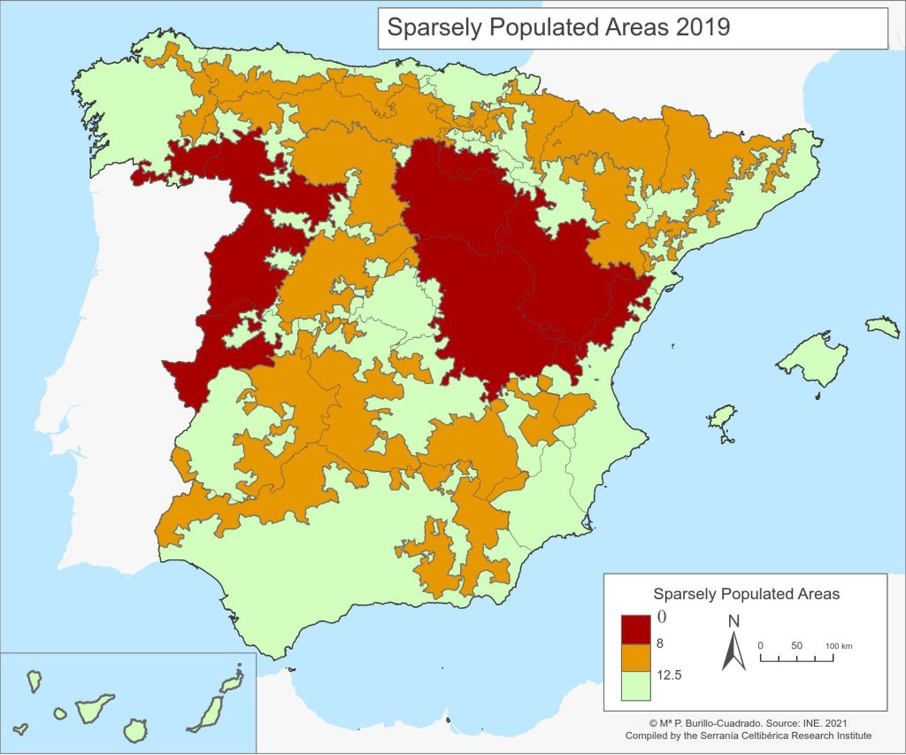 Map of ‘Depopulated Spain’ by population density in 2019. Source: Spanish Red Cross.
From this perspective, accessibility maps take on enormous explanatory value. They serve not only to visualise infrastructure, but also to reveal patterns. Where connectivity is highest, the greatest opportunities and the greatest demographic resilience are also typically concentrated. Where travel times increase and the network loses its reach, the risk of territorial fragility rises. Cartography, when used effectively, is not merely a tool for representation. It is a decision-making tool.
For this reason, the debate on depopulation should incorporate the spatial and functional dimensions much more strongly. It is not enough to promote generic incentives, launch calls for proposals or set broad objectives. Action must be taken on the specific conditions that make daily life viable or unviable in the region. And amongst these conditions, mobility occupies a central position.
There will be no single solution for all contexts. Each territory requires a specific analysis. A valley council with a certain degree of internal cohesion is not the same as an extremely dispersed area; a tourism-based area is not the same as one heavily dependent on regional services; an ageing territory with no generational renewal is not the same as one with a population that could potentially be retained if access to employment were improved. This is precisely why planning must be territorially intelligent.
The good news is that today there are tools, methodologies and technical capabilities to do this better. It is possible to combine accessibility analysis, network modelling, flexible operational design, scenario assessment and impact indicators. It is possible to prioritise investments where they generate the most cohesion. It is possible to redesign services to respond to real mobility patterns rather than perpetuating historical inertia. And it is also possible to communicate the problem more honestly: not as an inevitable demographic fate, but as a challenge of connectivity, opportunities and territorial organisation.
Ultimately, that is what is at stake. Rural depopulation cannot be tackled solely with talk of roots or identity, however legitimate that may be. It is tackled by making a functional, accessible and competitive life possible in the region. It is tackled by reducing the distance between home and opportunity. It is tackled by ensuring that living in a rural environment does not mean accepting a permanent penalty in terms of time, services and development options.
That is why, if we truly wish to discuss territorial cohesion, it might be worth reformulating the initial question. Perhaps the problem is not merely how many people remain in rural areas. Perhaps the decisive question is another: to what extent are we designing mobility systems capable of connecting these people with the range of opportunities they need to stay?
Because where there is insufficient accessibility, depopulation advances. But where mobility is understood as an essential part of the region’s infrastructure, a different possibility begins to emerge: that of sustaining the population not through inertia, but through a real capacity to live, work and plan for the future.
That should be the focus of the debate.
Javier Fernández Hevia / Geographer / Vectio
About Vectio
At Vectio, we focus on effective planning for sustainable mobility; we are experts in this field. Throughout our nineteen years in business, we have always maintained a commitment to innovation, embracing the technological solutions most sought after by our clients. We firmly believe that, having successfully completed over 1,500 projects, what sets us apart from any other company in the sector is our use of the best technology for capturing and analysing traffic and mobility data.
