

In mobility planning, there are many simple solutions to transport problems: changing the direction of travel on a street, increasing signage, reducing speed or creating a protected cycle lane. Each can be more or less successful and may or may not change the urban perception of the areas concerned.
However, the easiest and at the same time most useless solution is to make “one more lane”; in fact, for the last 70 years “adding a lane” has been the most common way in which a seemingly rational solution to congestion has been put forward.
However, it is clear that “one more lane” actually equals to more traffic and this has also been a tool to the most repressive and discriminatory policies.
For example, in the United States it has been used to exacerbate the spatial racial segregation. Indeed, the generation of traffic and its management is a direct consequence of the century-long effort to separate whites from blacks.
Before the Civil War, whites and blacks had to live in close proximity so that the former could control and coerce the labor of the latter. With the abolition of slavery this relationship declined, spatial segregation became the norm, and more blatant laws gave way to more subtle policies. ‘Redlining’ was an urban planning practice whereby the most ‘troubled’ areas of the city (i.e., those with the largest homeless and/or black populations) were red-lined on municipal maps and, as a consequence, these areas were denied public services and capital investment by banks and white individuals were strongly discouraged. Post-war urban regeneration programs were a ploy to demolish buildings in the worst neighborhoods and to displace large numbers of black citizens (hence the novelist and African-American civil rights activist James Baldwin’s assertion that “urban renewal means Negro removal”).
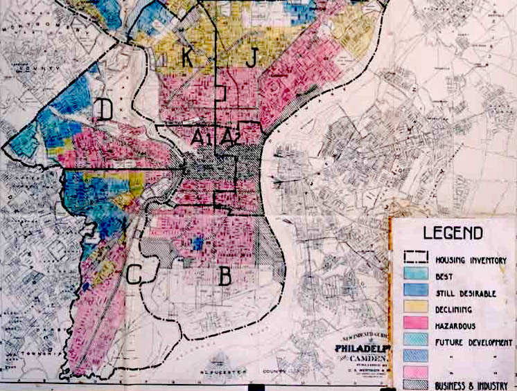
After World War II, when Eisenhower pushed for the construction of the vast Interstate Highway System and a great internal migration from south to north was taking place, local politicians had the possibility, on the one hand, to reinforce tacit divisions by creating dividing lines, veritable impassable geographical borders, and, on the other hand, to destroy entire neighbourhoods deemed undesirable and contain their expansion. The “one more lane” policy was a means by which to subsequently further bulldoze and isolate non-white neighbourhoods.
The results of the creation of these dividing lines are still visible in the contemporary urban fabric of many, many American cities, reflecting decades of discriminatory policies and racism, but also the power of the infrastructure itself to segregate.
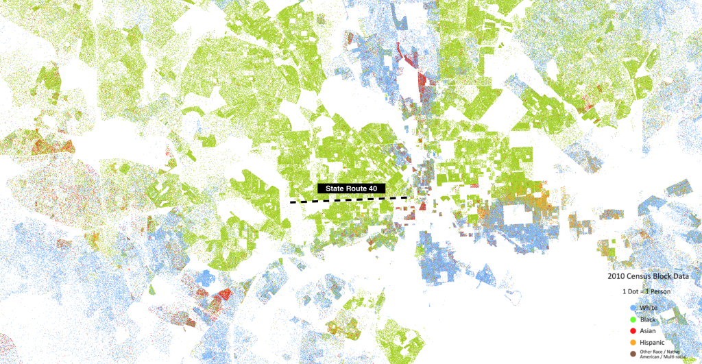
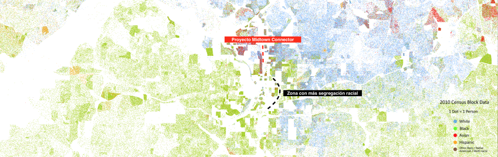
Dustin Cable of the Weldon Cooper Center for Public Service at the University of Virginia has developed a dot map showing 308,745,538 dots, one for each person residing in the United States where they were counted during the 2010 Census. Each dot is colour-coded according to the person’s ethnicity.
One of the cities where this separative urban planning has been used the most and continues to bear its damaging fruit is undoubtedly Detroit. The Eight Mile Road is perhaps the most emblematic and well-known road/border separating the eponymous black neighborhood and the white neighbourhood of Oakland. In addition to the road, to ensure that nearby vacant land was occupied by white single-family villas, it was decided after World War II to build an 800-metre long, 1.5-metre-high concrete wall to further establish the division between the two ethnic groups.


Baltimore is another American city where road construction was intended to divide (and not unite) two parts of the city. In the 1950s, with the rise of automobiles, it was decided to reduce the pressure on major roads by building new urban highways. This was an opportunity to remove and isolate supposedly marginal neighbourhoods. Thus, State Route 40 was born, an artery which, according to the urban planners of the time, would have played a crucial role in Baltimore’s urban expansion, but which, over time, has only retained its frontier status (hence the name “road to nowhere”).
It is interesting to note that the neighbourhood divided by this road was not a conflict-ridden neighbourhood, but a middle-class neighbourhood that was considered a ghetto only because of the colour of the people who lived there. To make room for this road, houses, churches and shops were destroyed, and many people had to leave the neighbourhood. In addition, the characteristics of this connection did not allow any communication between the neighbourhood and the centre of Baltimore, as it is a road at a lower level, with no exits and a destination that makes little sense.
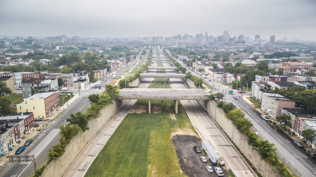
Creating solutions for these roads/frontiers is not easy because, in addition to the necessary political consensus, technical solutions are not always feasible, as these infrastructures are often too large to be replaced by parks or services and too expensive to demolish.
The former Secretary of Transportation in the Obama Administration has defined three basic principles for achieving feasible goals:
– use transportation to expand opportunities for and within communities.
– recognise neighbourhoods that have been harmed and work to strengthen them.
– build new infrastructure to serve the communities they pass through.
So, the key concepts are clear: that road infrastructure is not the primary cause of segregation, but has been a tool to amplify it, and that new mobility developments must put not only the individual but especially communities at the centre, thus avoiding the privatisation of the act of getting around and that in the generalisation of the standard individual only the needs of the ruling class are accepted.
Along these lines, the Midtown Connector project is being developed in Atlanta: the challenge is to replace part of a large urban highway with fourteen lanes and traffic jams during many hours of the day with a 10-block green space. The goals of the project are to reconnect the two sides of Midtown, improve traffic and road safety, provide better access for pedestrians and cyclists and offer environmental benefits such as stormwater retention and improved air quality.

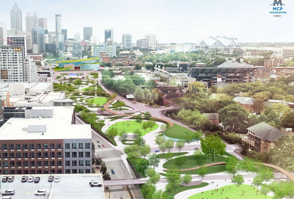
It is true, however, that the area of greatest complexity and segregation is further south (the Downtown Connector), and the project strip divides an area inhabited mostly by whites and one that is sparsely populated due to the presence of the Georgia Institute of Technology University Campus.
At the European level, the policy of “one more lane” to divide and isolate conflict areas has generally not been ethnically discriminatory. In fact, urban development between the 1950s and 1970s followed a profit-oriented vision that did not deliberately favour racial segregation. Moreover, it is necessary to underline how some infrastructures that later became boundaries were designed based on roads and bridges already existing at a time when urban development had not reached contemporary levels.
This is the case of Madrid, for example. Observing the income data by census section published by the National Institute of Statistics, the areas with the lowest incomes are located outside the M-30. Again, it should be noted that infrastructure does not create segregation, but it is an additional obstacle to managing equitable urban development.
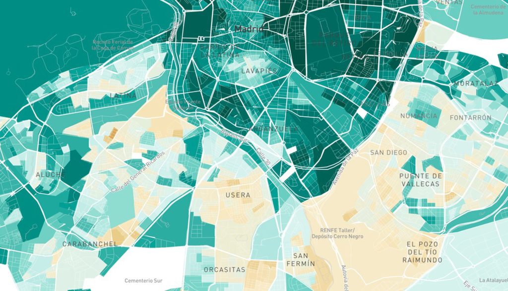
Over the years, the various flyovers have been demolished and the last one will be demolished in 2023 and replaced by a large green corridor that would benefit some 150,000 residents. This bridge, called Scalextric de Vallecas, has an interesting history: it was built in 1977 to drive traffic from the M-30 in an area where a bridge already existed in the 18th century (the Puente de Vallecas that has originated the toponym) to cross the Abroñigal stream (tributary of the Manzanares river, buried since the 1970s by the M-30); with urban development it has become a real border between a high-income area and a low-income area (the inhabitants of Puente de Vallecas, the second poorest area of Madrid, have an average annual income of 9. 545 euros, according to INE data for 2019, Retiro, on the other side of the flyover, doubles that income to 21,504 euros on average); with the undergrounding of the M-30 a tunnel was created underneath with three lanes in each direction creating a doubling effect of the motorway (underground and open-air traffic, perpetuating the “one more lane” policy).
The demolition project is based on the idea of diverting traffic to the underground bypass and the two outer belts (the M-40 and the M-50). In fact, traffic studies have pointed out that most of the traffic passing through Puente de Vallecas does not come from the city of Madrid, but is through traffic, because it is the shortest way to cross from south to north.
There is hope that the project can be an opportunity to recover the use of the area, mend the border that has been open for many years and transform it into a public space that intercepts the needs of the neighbourhood communities and the new trends of collective and sustainable mobility.